 How Storm Barra will impact on the UK. Image from © OpenStreetMap contributors
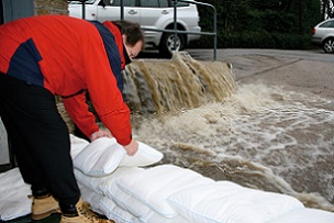 FloodSax alternative FloodSax keeping torrential floodwater at bay
Everything the Met Office is saying about storm Barra
The second storm of the winter is set to hit the UK tomorrow after the first brought chaos across the country.
Around 3,000 people still remain without electricity after Storm Arwen’s 98mph winds tore down power lines causing cuts on Friday, November 26.
Storm Barra will hit Ireland early tomorrow and then race across all of the UK during the day bringing high rains, heavy rain and snow to most areas.
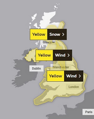
The full extent of the bad weather caused by a deep area of low pressure can be seen on this Met Office map courtesy of © OpenStreetMap contributors.
But that won’t be the end of it as the outlook for Wednesday to Friday means it will remain unsettled with longer spells of rain with coastal gales and snow restricted to the high ground in the north.
It means there will be a risk of flooding and people are urged to be prepared as councils have no responsibility to provide sandbags. One alternative that many councils now recommend is FloodSax alternative sandbags which are space-saving to store and quick and easy to deploy.
Here’s everything the Met Office is saying about Storm Barra.
It will come in off the Atlantic and hit the Republic of Ireland hardest. As the storm begins to weaken it will bring strong winds and rain into the UK with the rain turning to snow across northern England and Scotland.
The Met Office has issued a series of yellow national severe weather warnings for wind and snow which affect most of the UK.
Frank Saunders, Chief Meteorologist at the Met Office, said: “Strong winds arriving across the west through Tuesday morning will spread inland and reach eastern areas through the afternoon and early evening. Gusts of 45-50 mph are expected widely with 60-70 mph in exposed coastal locations. The strongest winds will ease across inland areas into the overnight period.”
Deputy Chief Meteorologist Brent Walker added: “A band of rain will turn to snow across northern England and Scotland through Tuesday with 2cm to 5cm of snow expected to accumulate quite widely across the warning area, but locally this could reach 10cm, particularly in parts of the Southern Uplands and Highlands.”
He added: “Strong south-easterly winds will also lead to snow drifting in places, particularly over the highest routes, adding to poor visibilities.”